
The Best Mountains to Climb: 30 UK Peaks Graded from First Summit to the Cuillin, and 12 World Classics to Aim For Next
Written by James, founder of Flaming Phoenix and the maker of Phoenix Bars. Updated September 2026.
Quick answer: the best mountains to climb in the UK, in order of difficulty, are Pen y Fan, Cat Bells and Ben Lomond for a first summit; Snowdon (Yr Wyddfa), Scafell Pike and Ben Nevis as the three national high points; Helvellyn, Cadair Idris, Buachaille Etive Mòr, Suilven and Slieve Donard as the classic mountain days; and Tryfan, Crib Goch, the Aonach Eagach, An Teallach, Liathach and the Skye Cuillin for scramblers. Of the three highest, Ben Nevis is the longest, Scafell Pike the hardest to navigate and Snowdon the easiest to climb but the busiest. Beyond Britain, the classic first big mountains are Toubkal (4,167 m, two days from Marrakech), Kilimanjaro (5,895 m, a walk if you acclimatise), the Breithorn and Gran Paradiso as first Alpine 4,000 m peaks, and Island Peak, Mera Peak and Aconcagua as the step into expedition altitude. Every peak below has its height, standard route, distance, ascent, time and grade from the official route data, and the grades are explained, because "best" depends entirely on what you can do.
How the grades work, and how this list was built
Most "best mountains" pages mix a two-hour hill with a roped ridge and call both "moderate". This page uses a simple ladder. A walk means a path to the top, however steep. A grade 1 scramble means hands on rock with real exposure but no rope for most people (Striding Edge, Tryfan). A grade 2 or 3 scramble means sustained exposed rock where many people rope up (Aonach Eagach, the Cuillin). A climb means a graded rock route. The Scottish figures and grades below come from Walkhighlands (which grades on a 1 to 5 scale), the English and Welsh ones from the National Trust, the Lake District and Eryri national park authorities and the British Mountaineering Council, and the Northern Irish ones from WalkNI, all checked in September 2026. I make high calorie bars that people carry up most of these mountains, so I hear about them every week; I am not affiliated with any of the organisations named.
Snowdon, Scafell Pike or Ben Nevis: which is hardest?
Ben Nevis (1,345 m) by the Mountain Track from Glen Nevis is 17 km with 1,352 m of ascent, seven to nine hours, and the summit plateau in cloud or snow is the most dangerous ground of the three: the walk-off needs compass bearings to avoid Five Finger Gully and Gardyloo Gully. More than 130,000 people reach the top each year.
Scafell Pike (978 m) by Hollow Stones from Wasdale Head is the shortest (roughly 9 km round trip, around 900 m of ascent, five hours) but the hardest to navigate: a boulder-field summit with confusing cairns, and the Corridor Route from Seathwaite (11.5 km, about five hours) is longer and more interesting. Around a quarter of a million people climb it each year.
Yr Wyddfa, Snowdon (1,085 m) is the easiest to climb and the busiest, with more than 600,000 ascents a year. The Llanberis Path is 14.5 km with 975 m of ascent in about seven hours, the Pyg Track from Pen-y-Pass is 11 km with 895 m in six, and the Watkin Path from Nant Gwynant is the most demanding with over 1,000 m of climbing. Book Pen-y-Pass parking in advance or take the Sherpa'r Wyddfa bus.
So: Snowdon is the easiest, Scafell Pike the trickiest to find your way up and down, Ben Nevis the longest and, in winter or cloud, the most serious. If you are doing all three in 24 hours, my Three Peaks Challenge food guide covers the part most people get wrong.
First summits: the best mountains for beginners in the UK
Pen y Fan (886 m, Bannau Brycheiniog). The highest peak in southern Britain by the Pont ar Daf path is 6.4 km and about three and a half hours, moderate, with steep steps near the top. The most climbed mountain in Wales after Snowdon.
Cat Bells (451 m, Lake District). About 5 km and two to three hours from Hawes End, with a short, easy scramble near the top and the whole of Derwentwater below. The classic first fell.
Ben Lomond (974 m, Loch Lomond). The most southerly Munro and the most climbed: 12 km, 990 m of ascent, four and a half to five and a half hours from Rowardennan on a good path, with the Ptarmigan ridge as a descent for the confident.
Schiehallion (1,083 m, Perthshire). A 10 km, 731 m, four to six-hour walk on a path rebuilt by the John Muir Trust, finishing on a quartzite boulder field. The mountain where Maskelyne weighed the Earth in 1774.
Ben Hope (927 m, Sutherland). The most northerly Munro: 7.5 km, 946 m and four to six hours from Strathmore, short, steep and remote.
Skiddaw (931 m, Lake District). England's fourth highest by the Jenkin Hill path from Keswick: about 10 miles and five to six hours on a clear, stony path all the way, the gentlest of the big Lakeland tops.
Pen-y-ghent (694 m, Yorkshire Dales). A 10 km circular from Horton-in-Ribblesdale with a short, easy scramble on the nose. The best first mountain in Yorkshire and one third of the Three Peaks.
Slieve Donard (850 m, Mourne Mountains). Northern Ireland's highest via the Glen River from Donard car park in Newcastle: about 9 km round trip, 800 m of ascent, four to five hours, graded very strenuous by WalkNI but on a flagged path almost all the way, with the Mourne Wall as a handrail to the summit cairn.
Mam Tor (517 m) and Kinder Scout (636 m) in the Peak District are the equivalents for the Midlands: Mam Tor is a two-hour hill from Mam Nick, Kinder Scout a 12 km, five-hour circular from Edale via Jacob's Ladder with real navigation on the plateau.
Classic mountain days
Helvellyn (950 m, Lake District). By Striding Edge from Glenridding it is a grade 1 scramble and the nation's favourite walk; by the Swirls path from Thirlmere it is a three to four-hour walk with none of the exposure. Two very different mountains.
Great Gable (899 m, Lake District). Roughly 9 km and four hours from Wasdale Head via Sty Head, with a boulder-strewn summit and the best view of Wasdale in the district. The Remembrance Sunday mountain.
Blencathra (868 m, Lake District). Hall's Fell Ridge is a grade 1 scramble straight to the summit; Sharp Edge is harder and has killed people in the wet; Blease Fell and Scales Fell are easy grass. One mountain, every grade.
Cadair Idris (893 m, Eryri). The Minffordd Path from Dôl Idris is 9 km with 788 m of ascent in six hours, past Llyn Cau under the cliffs of Craig Cau; the Pony Path from Ty Nant is the easier, longer way. The legend says you wake on the summit a poet or a madman.
Glyder Fawr (1,001 m) and Glyder Fach (994 m, Eryri). From Ogwen via Llyn Idwal and Twll Du (the Devil's Kitchen) to the lunar summit rocks and the Cantilever Stone, six or seven hours for the circuit with Tryfan, and Bristly Ridge as an optional hard grade 1 scramble.
Buachaille Etive Mòr (1,022 m, Glen Coe). The most photographed mountain in Scotland: 13 km, 1,110 m and seven to nine hours from Altnafeadh via Coire na Tulaich, whose headwall is an avalanche blackspot in winter.
Cairn Gorm (1,245 m) and Ben Macdui (1,309 m, Cairngorms). Cairn Gorm via the Northern Corries is 11 km, 775 m and five to six hours; Ben Macdui, Britain's second highest, is a 29 km, nine to eleven-hour day from Linn of Dee across an arctic plateau that has its own weather and its own ghost. Both are serious in winter.
Suilven (731 m) and Stac Pollaidh (613 m, Assynt and Coigach). Two small mountains that feel enormous: Suilven is 20 km and 947 m in seven to nine hours from Glencanisp near Lochinver; Stac Pollaidh is 4.5 km and 510 m in two to four hours, with a short, exposed scramble to the true western summit that Walkhighlands ranks among the hardest on the mainland.
Cross Fell (893 m, North Pennines). The highest point in England outside the Lake District, home of the Helm Wind, reached from Dufton on the Pennine Way via Great Dun Fell.
High Willhays and Yes Tor (621 m and 619 m, Dartmoor). The highest ground in southern England, inside an army firing range, so check the Dartmoor firing notice before you go.
Ingleborough (723 m) and Whernside (736 m, Yorkshire Dales). The other two of the Three Peaks; the route up Ingleborough from Clapham past Gaping Gill is one of the finest walks in the north.
The hardest mountains to climb in the UK
Tryfan (917 m, Eryri). The North Ridge is a grade 1 scramble with grade 2 moves, and even the easiest route from Bwlch Tryfan is a scramble. The Adam and Eve summit stones are the reward. Mountain rescue is called to its gullies constantly.
Crib Goch (923 m, Eryri). A 500 m knife-edge at grade 1 with three pinnacles and no escape route until Bwlch Coch, usually climbed as part of the six to ten-hour Snowdon Horseshoe. Not in wind, wet, snow or mist.
Striding Edge and Sharp Edge (Lake District). Grade 1 scrambles on Helvellyn and Blencathra respectively; the Bad Step on Sharp Edge is the crux and the rock is treacherous when wet.
Jack's Rake (Pavey Ark, Langdale). A grade 1 scramble that Wainwright called just about the limit for the ordinary fell walker.
Aonach Eagach (967 m, Glen Coe). The narrowest ridge on the British mainland, 9.5 km, 1,100 m and eight to nine hours at grade 2 to 3, with no safe way off once committed and a gully at the end that has claimed lives.
An Teallach (1,062 m, Wester Ross). The finest mountain on the mainland: a 20 km, 1,415 m, nine to ten-hour traverse from Dundonnell over the Corrag Bhuidhe pinnacles, which are a scramble with a bypass path that is itself sensationally exposed.
Liathach (1,055 m, Torridon). 11.5 km and 1,326 m in eight to ten hours over the Am Fasarinen pinnacles, sustained exposed scrambling; Walkhighlands says hire a guide if unsure.
Sgùrr nan Gillean (964 m, Skye). The South-East Ridge from Sligachan is 12 km, 985 m and five to seven hours of difficult, exposed scrambling on which some walkers want a rope.
The Inaccessible Pinnacle (986 m) and the Cuillin Ridge (Skye). The In Pinn is the only Munro that needs a rock climb (a Moderate) and an abseil. The full traverse of the Cuillin is 12 km of continuous ridge with more than 4,000 m of ascent and descent, several short rock climbs, nine to fifteen hours on the crest and usually a bivouac. The hardest mountaineering objective in Britain.
If you are working up this ladder, my guide to the best hikes in the UK covers the walking end in more detail, including the coast and lowland classics that are not mountains at all.

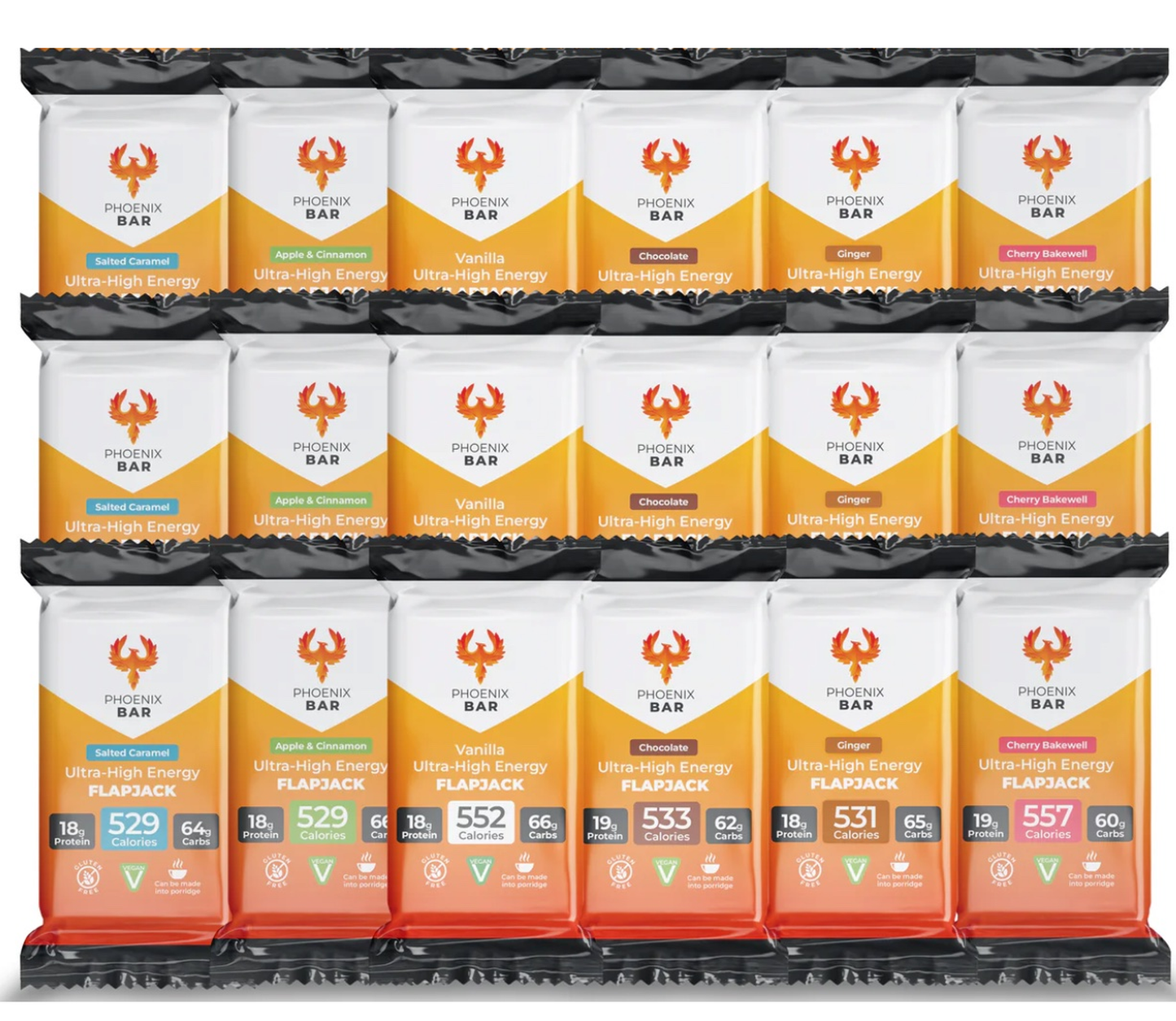
Phoenix Bars: Up to 557 Calories Per Bar
Highly compact, low-volume, calorie-dense bars. Soft, easy to eat whole or as a warm porridge. Vegan, gluten-free and contain up to 66g of carbohydrates, 19g of protein & 8 vitamins & minerals.
The best mountains to climb in the world (for UK walkers going bigger)
First big mountains, no technical skills required. Toubkal in Morocco (4,167 m) is two days from Imlil via the refuges at 3,207 m, with a 960 m summit morning; crampons in winter, a guide strongly advised. Kilimanjaro in Tanzania (5,895 m, the highest free-standing mountain in the world) is a five to nine-day walk depending on route, best in the dry seasons of late June to September and December to early March, with summit success around 70 to 80 percent and altitude sickness affecting most people to some degree; the longer routes (Lemosho, Northern Circuit) acclimatise better. Mount Fuji (3,776 m) is climbed by hundreds of thousands in its short July to September season, with daily caps and fees on the Yoshida trail. Mount Kinabalu in Borneo (4,095 m) is two days with a mandatory guide and a strict daily cap of 130 climbers. Musala in Bulgaria (2,925 m, highest in the Balkans) is a day from the Borovets gondola, and Mount Olympus in Greece (2,917 m) is two days from Prionia via the refuge, with a class 3 scramble to the true summit that most people skip.
First Alpine 4,000 m peaks. The Breithorn (4,164 m) from the Klein Matterhorn lift is the easiest 4,000 m summit in the Alps, a glacier plateau and a 35-degree snow slope, roped and with crampons. Gran Paradiso (4,061 m, the only 4,000 m peak wholly in Italy) is a refuge night at 2,700 m and a glacier day graded F+ with easy rock on the summit block. Triglav in Slovenia (2,864 m) is a via ferrata scramble with hut nights. Mont Blanc (4,806 m) by the Goûter route is two days of technically easy but arduous glacier and ridge that needs fitness and acclimatisation; six-day itineraries succeed far more often than three-day ones, and around 20,000 people attempt it a year.
Expedition altitude. Elbrus (5,642 m) is not technical but is high, cold and windy, with lifts to 3,800 m; Kala Patthar(5,644 m) is the highest point most people reach without a permit on the Everest Base Camp trek; Island Peak (6,165 to 6,189 m depending on the survey) and Mera Peak (6,476 m) are Nepal's classic first 6,000 m summits with a fixed rope and a jumar; Pico de Orizaba (5,636 m) and Cotopaxi (5,897 m) are the crevasse-light volcano climbs of the Americas; Mount Kenya's Point Lenana (4,985 m) is the trekking summit of Africa's second highest mountain; and Aconcagua (6,962 m, the highest non-technical mountain in the world) is a three-week expedition with a 30 to 40 percent success rate, almost all of it decided by acclimatisation. Mount Whitney (4,421 m) is a 22-mile, 1,860 m day in California with a permit lottery.
The first rule for any of these is that fitness does not protect you from altitude sickness; acclimatisation does. My guide to how to acclimatise before a high-altitude expedition sets out the sleeping-altitude rules the medical bodies agree on and the day-by-day profiles for Kilimanjaro, Toubkal, Mont Blanc, Everest Base Camp and Aconcagua.
Eating on a mountain
A big British mountain day burns 3,000 to 5,000 kcal and a summit day at altitude far more, at exactly the moment appetite disappears: above 3,000 m most people eat several hundred calories a day less than they need without noticing, which is why expedition climbers lose so much weight. The climbing calorie calculator will give you a figure for your own day, and my mountaineering nutrition guide explains what to carry when the stove is the only warm thing for miles. The practical answer on both British and big mountains is dense food you can eat with cold hands and no appetite: our high calorie energy bars are 120 g for 527 to 557 kcal, stay soft at minus 45 (a customer took them to the South Pole and said exactly that), and turn into porridge with hot water at a hut or a high camp. They are the high calorie protein bars that the Kilimanjaro and Everest Base Camp food guides below are built around, and the same product customers at home buy as high calorie bars for weight gain, which is the honest measure of how much energy is in one; the best energy bars for expeditions comparison ranks them against the alternatives by calories per gram and cold performance. For specific objectives, I have separate food guides for Kilimanjaro, Everest Base Camp, Aconcagua, Manaslu and Denali, plus the expedition kit list and a note on energy bars for rock climbing for crag days. A couple of high calorie snack bars in the lid pocket is the cheapest insurance on any mountain on this page.
Season and safety
UK mountains hold snow from November to April and the highest tops into June; every scramble above becomes a winter climb needing an ice axe, crampons and the skills to use them. Check the Mountain Weather Information Service, carry a map, compass and head torch, register your phone for the 999 text service, and tell someone your route. Mountain rescue in Britain is free and run by volunteers. For the world peaks, book with operators who follow the medical acclimatisation guidelines, insure for the altitude you will reach, and remember that the summit is optional and the descent is not.
Frequently asked questions
Which is harder, Snowdon or Scafell? Scafell Pike is harder: it has no gentle path, a boulder-field summit that is confusing in cloud, and longer, rougher approaches from Borrowdale or Langdale. Snowdon has six graded paths, a café and a railway. Ben Nevis is harder again because of length and the plateau navigation.
What is the most climbed mountain in the UK? Yr Wyddfa (Snowdon), with more than 600,000 ascents a year according to the national park. Pen y Fan is second by most estimates, then Scafell Pike and Ben Nevis (over 130,000 a year).
What are the top 10 hardest mountains to climb in the UK? The Inaccessible Pinnacle and the Cuillin Ridge, Sgùrr nan Gillean, the Aonach Eagach, An Teallach, Liathach, Tryfan's North Ridge, Crib Goch, Sharp Edge on Blencathra, Striding Edge on Helvellyn and Ben Macdui in winter, roughly in that order. Stac Pollaidh's true summit and Jack's Rake are the honourable mentions.
Which UK mountain is easiest to climb? Pen y Fan from Pont ar Daf, Cat Bells, Ben Lomond and Skiddaw are the easiest proper mountains; Mam Tor and Arthur's Seat are easier still but technically hills.
Can a beginner do Scafell Pike? Yes, on a clear summer day with proper footwear, a map and compass, food, and an early start from Wasdale Head; allow five to six hours. Not in cloud without navigation skills, and not as your first ever hill.
Can a beginner walk up Snowdon? Yes, by the Llanberis Path (14.5 km, about seven hours return) with the right kit and a weather check. Avoid Crib Goch and the Watkin Path's final scree section until you have more experience.
Where is the best place to go climbing in the UK? For hillwalking and scrambling, Eryri (Snowdonia), the Lake District and Glen Coe. For rock climbing, the Peak District gritstone edges, the Llanberis Pass, Glen Coe and the Cuillin of Skye.
What is the best mountain to climb for a beginner outside the UK? Toubkal in Morocco for a first 4,000 m summit, Kilimanjaro for a first 5,000 m one on a long route, and the Breithorn for a first Alpine peak with a guide.
What are the top 5 hardest mountains to climb in the world? K2, Annapurna, Nanga Parbat, Kangchenjunga and Everest are usually named, on death rates and technical difficulty; none is a mountain anyone on this page should be aiming at next.
Flaming Phoenix is not affiliated with Walkhighlands, the National Trust, the BMC, any national park authority, WalkNI, the John Muir Trust or any guiding company or park authority named here. Route data was checked in September 2026; conditions change, so check the forecast and take the right kit.


Flaming Phoenix



Contact Us
Widerruf erklären
Füllen Sie das folgende Formular aus, um Ihre Widerrufserklärung abzugeben.

